I normally don’t cover consumer products, but am becoming obsessed with how my car GPS decides the route to take.
In the course of my “day job”, we are pros in what we do. One of Harvard Partners’ new associates recently asked if (collectively) we know everything there is to know about data centers.
The simple answer is NO. There are simply projects we may know about and haven’t done, like co-generation, or placing a data center in Finland and cooling with seawater.
When it comes to building/renovating a data center, running a data center, ITIL processes, etc, we have it covered, and it’s something we’re proud about.
When it comes to my car GPS, it is another story.
I’ve really like my GPS. I prefer to have the GPS built in, as it just seems to work better. I have one handheld for a pre-GPS car, and it suffers from being under powered. It tends to give directions just a little late….saying, “You are turning right in 50 feet” when it should be saying, ”You should have turned back there.”
I know the GPS were originally set up for military activities, and that the signals have been dumbed down so our enemies can’t use our GPS systems for targeting us. I hope the military GPS systems route better than my cars does.
What I don’t “get” is how the GPS in my car picks its route.
For example, on a recent Friday night I decided to visit some friends in another state. They wanted to give me directions…but “No, I’ll punch it in” was my response.
So…off I go. I’m working near a freeway on-ramp, and expected the GPS to quickly dump me on the freeway. Nope, it knew better.
In fairness, sometimes the GPS takes me in ways I’d never go and it’s better. Also, the GPS always gets me there.
So I blindly let it lead me.
As I drive and drive and drive, I start imagining how the GPS decides a route. It must get out a map, a big ruler and go to the kitchen table. Then it draws a line between the start and finish, and then it must stare at the map. Eventually it must decide how to route me. Isn’t this how AAA used to make TripTiks?
When I look at a map, I see if there are areas I want to visit, or avoid. Like going along the ocean (always nice), or staying away from cities.
On this recent night, the GPS steered me around the freeway (blue) in favor of a “main road” (lavender. ) Arguably the main road was straighter…albeit stop and go, and through neighborhoods with steel bars on the windows.
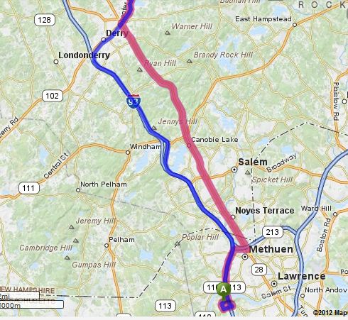 Mapquest
This added at least an hour to my trip. I eventually called my trusted business partner for directions…and he (thankfully) quickly routed me back to the freeway.
So, here are my suggestions for GPS makers:
- Take your application OUT of the car, and internet enable it in the Cloud.
- Make the car display only, with directions for one hour commute time (if the internet connection is disrupted)
With your application in the Cloud, you can now:
- Give me accurate maps
- Check crime data bases and keep me out of iffy neighborhoods
- Route me wherever I want. You may be able to route me to generic food places…I want to go to McDonalds, Home Depot, Best Buy by name.
- Let me know about any grand openings
- Know the speed limit, and the actual traffic speed - allowing me to always route in the fastest manner
- Check my calendar, and if I have time let me take the scenic route
And to our military:
- Our men and women in the Armed Forces may not need to worry so much about going through a bad neighborhood in an armored vehicle….and I hope they get routed better than I do. Time is of the essence for them.
- We recently gave out guns to the bad guys across our borders. Why not just distribute some of the low end GPS systems instead? They’ll lose interest before they get to their destination.